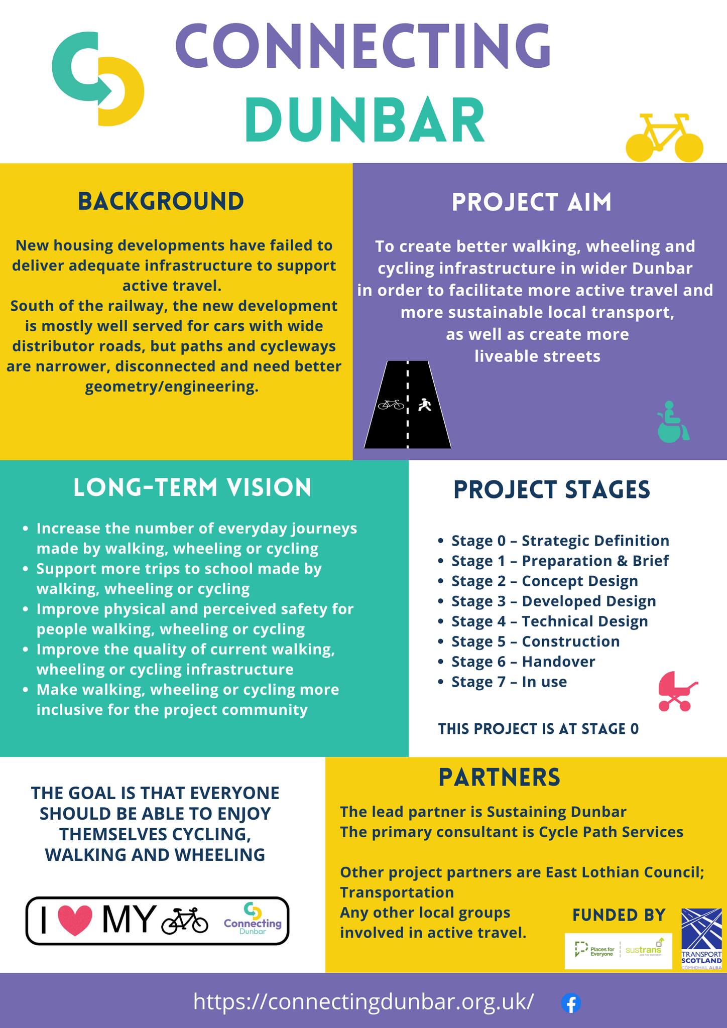
Background
The project aims to create better walking, wheeling and cycling infrastructure in wider Dunbar in order to facilitate more active travel and more sustainable local transport, as well as creating more liveable streets.
The lead partner is Sustaining Dunbar, a well established community development trust with a focus on climate, nature and sustainability.
The project is currently funded by the Places for Everyone programme delivered by Sustrans Scotland, on behalf of Transport Scotland.
The problem
Project summary
Review the current provision in order to shape a more useful and attractive active travel network that people actually want and will use.
Engage the community to map the current network and create an inventory of problems and issues that people want to see addressed.
Form a prioritised set of more detailed proposals and a fully costed plan for action that would include improvements to the public realm (green infrastructure), working closely with all the relevant stakeholders, landowners and statutory bodies.
Business Case
New housing developments in Dunbar have failed to deliver adequate infrastructure to support active travel, and a lack of attention to off road cycling provision. Meanwhile the population has more than doubled in the last 20 years and placed increasing traffic pressures on the historic town centre. South of the railway, the new development is mostly well served for cars with wide distributor roads, but paths and cycleways are narrower, disconnected and suffer poor geometry/engineering. Some existing surfaced paths around the new housing areas could be improved in terms of width, connections, signage, coherence.
The local population is fairly heterogeneous demographically but as it has aged, public realm improvements have not kept pace especially for those who choose or don’t have non-motorised transport or may have a disability. Even simple pedestrian connections to local rail and bus “journey hubs” are incomplete, or inadequate. Additionally a number of quiet roads exist in and around the periphery of the town that lend themselves to roadspace reallocation.
The Dunbar area is mixed in terms of SIMD, though none are in the lowest 20% overall, there are a number of areas that are in decile 1 and 2 in terms of Geographical Access Domain
We think that there is a great opportunity particularly for these more peripheral communities to provide cost effective interventions for journeys to the schools, to use local services in the town, and improve access to the railway station.
Aims & Objectives
Increase the number of everyday journeys made by walking, wheeling or cycling
The aim is to substantially increase the numbers of those walking, wheeling and cycling while reducing numbers opting to use the car for short journeys into the town centre and nearby facilities. This will be the main focus, by addressing the gaps in provision and by better enabling multi modal journeys, e.g. to Dunbar station, reducing inconveniences, shortening journey times and improving safety at dangerous junctions.
Support more trips to school made by walking, wheeling or cycling
Dunbar already has very high rates of walking and cycling to school, but these numbers are not sustained at the same high levels of wheeling and cycling when young people move from primary to high school and when they eventually leave school. We want to provide easier and faster routes to encourage behaviour change in these target age groups.
Improve physical and perceived safety for people walking, wheeling or cycling
Where improvements are made or new paths created, attention to the design characteristics that improve safety and the feeling of safety will be taken into account fully. In practice we will be looking to improve lighting for safety in public space using more environmentally sensitive approaches. We will consult local access groups and women’s groups and the schools to identify the issues that concern them most.
Make walking, wheeling or cycling more inclusive for the project community, taking into account all protected characteristics
We will work with other groups to ensure that the needs of all groups with protected characteristics are taken into account fully. We will identify accessibility groups with the council and as necessary womens focus groups and childrens focus groups to inform our equality impact assessment.
Improve the quality of current walking, wheeling or cycling infrastructure
Notwithstanding permissions, there appear to us to be a lot of relatively easy wins, many of which do not require large capital expenditure, such as signage, dropping kerbs, widening existing paths, lighting, and short link sections that are missing. There are also more significant interventions which includes whole new sections of path linking communities, and finally there are interventions in existing roads including roadspace reallocation (eg. Belhaven Road).
Positively impact an area identified by the Scottish Index of Multiple Deprivation (SIMD) as among the 20% most deprived
We recognise that there is a need for behaviour change interventions that specifically target more disadvantaged areas.
The Dunbar area is mixed in terms of SIMD, though none are in the lowest 20% overall, there are a number of areas that are in decile 1 and 2 in terms of Geographical Access Domain; namely West Barns, southern housing estates at Hallhill, and proposed housing estates at Hallhill North and South West.
You must be logged in to post a comment.